


NAVER Maps, Navigation
4.6581.00 Reviews
App Specs
- Version
- 6.9.1.3
- Updated On
- License
- Free
- Downloads
- 50,000,000+
- Developer
- NAVER Corp.
- Categories
- Maps & Navigation
- Platform
- Android, iOS
Screenshots

 Analysis by AppCompare
If you’ve ever found yourself lost in a new city or just need a reliable navigation tool, let me introduce you to NAVER Maps, Navigation. I've been using it for a bit, and I've got some thoughts. So, buckle up and let’s take a tour through its features, usability, and overall vibe.
Where it fits in my daily routine
I find a map app most useful before I leave, not only after I have already taken a wrong turn. With NAVER Maps, I like to search for the destination first, compare the available ways to get there, and then decide which option suits the day. That small pause matters when a journey includes a walk to a station, a transfer, and a final stretch on foot: the quickest-looking choice is not always the least stressful one.
A realistic example is a weekday trip to an unfamiliar appointment. I would check the address at home, look at the route options, and note where the final approach begins rather than waiting until I am standing outside a busy station. If I am driving, I would check traffic before setting off and compare it again if plans change. The app is most valuable when I treat it as a guide for decisions, rather than a screen to follow without thinking.
That habit also helps when several places are involved. For errands, I can look at each destination and consider the order that makes sense, instead of crossing town twice because I searched for one place at a time. I still use my judgment about opening hours, queues, and how long I want to spend walking; a route planner cannot know those personal priorities. But having the map visible while I plan makes those trade-offs easier to see.
Settings and checks that make a difference
Before relying on any navigation app in a new place, I check that I have selected the right travel mode. A route that is sensible on foot may be a poor choice by car, and a driving estimate is not a substitute for a public-transit plan. NAVER Maps presents different ways to travel, so I make a deliberate choice rather than assuming the first result matches what I intend to do.
I also take a moment to inspect the route itself, not just its headline time. For transit, I look at the transfer points and the walking sections around them. For driving, I treat live traffic as helpful context, not a promise that conditions will stay the same for the whole trip. If the route changes or I need to make an unplanned stop, I check the directions again when it is safe to do so.
Language is another practical consideration. The interface can be useful to visitors, but some English translations may be imperfect, as the original review notes. I would double-check an unfamiliar place name or instruction against the map and the surrounding labels rather than guessing. A little preparation—especially confirming the destination before leaving—can prevent a confusing search at the curb.
Worth Reading Before You Choose

Baby Panda World Brings Quick Play to Modern Phones, but Its Game Library Feels Busy

ESPN’s Live Game View Makes Following Close Games Easier

QuizzLand Review: A Good Fit for Short Trivia Breaks, Not Every Player

Basketball Stars: Multiplayer Is Fast, but Can It Recover When Matches Go Wrong?

WEBTOON Turns Phone Updates Into a Better Reading Routine

Link to Windows Runs on Shared Habits, Not Social Feeds
An Overview of NAVER Maps
So, what’s the deal with NAVER Maps, Navigation? This app is like your best travel buddy, always ready to guide you through bustling streets or serene countryside. It’s a product of Naver Corporation, a big name in Korea, and they’ve packed this app with a lot of nifty features.
First Impressions and Usability
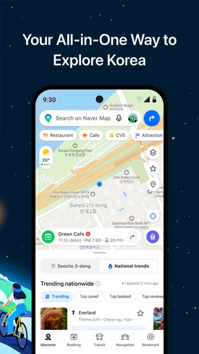
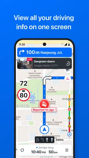
The first time I fired up the app, I was greeted by a clean and intuitive interface. The map is detailed, and the information is easy to digest. It's got this neat color scheme that’s easy on the eyes, which is a big plus if you're navigating late at night or early in the morning.
Getting started is a breeze. You can quickly find directions by entering your destination, and the app offers various route options, including walking, driving, and public transportation. I love how it provides multiple routes, so you can choose between the fastest or the most scenic path, depending on your mood.
Features That Stand Out
Now, let’s talk features. NAVER Maps is not just about getting you from point A to point B. It's about enhancing your journey. Here’s what really caught my eye:
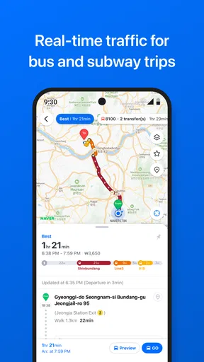
- Public Transport Integration: If you’re someone who relies on buses or trains, you’ll appreciate how seamlessly NAVER integrates public transport schedules and routes. It’s like having a personal transit guide in your pocket.
- Real-time Traffic Updates: This feature is a lifesaver. The app updates traffic conditions in real-time, helping you avoid those unexpected jams. Trust me, it’s saved me a ton of time!
- Street View and 3D Maps: For those who like to get a sense of their destination before arriving, the street view feature is super helpful. And the 3D maps give you a realistic feel of the area, which is great for visualizing your surroundings.
How I use those features more deliberately
The map view and route planner answer different questions. Street view is useful when I want to recognize the entrance or get a feel for the last block, while a 3D view helps me orient myself around a dense cluster of buildings. I use those views as a preview, then return to the route rather than leaving a visually rich mode open throughout a journey. That is a sensible trade-off when data use matters.
For a transit trip, I pay attention to the whole chain: the walk to the stop, the ride, any transfer, and the last walk. A route can look simple when reduced to a destination and an arrival time, but the transfer is where a visitor may feel least certain. Checking that section before departure gives me a chance to recognize the stop or station and avoid making a rushed decision on the platform.
For driving, the useful routine is different. I compare the route choices before moving, then let traffic information inform my decision without treating it as certainty. If a detour would make the journey more complicated than the delay, I may prefer the familiar route. No navigation app can remove the need to pay attention to signs, road conditions, and safe driving, and I would never adjust a route while the car is moving.
Choosing between NAVER and familiar alternatives
Compared with the map app already installed on a phone, NAVER Maps makes the most sense when its local map coverage and transit presentation fit the place I am visiting. The strongest reason to try it is not simply that it offers directions; it is the combination of public transport, traffic information, and map views in one planning workflow. For a visitor who wants to inspect a destination before walking there, those layers can be more useful than a bare line from start to finish.
That does not make it the automatic choice everywhere. If I am travelling in a region where another map service is already familiar, has the local detail I need, or is easier for me to read, I would use that instead. If I depend on English labels, I would test a few searches before building a complicated day around this app, because imperfect translation can make place names and instructions harder to interpret. Familiarity is a real advantage when I need to make a quick decision outdoors.
I would also distinguish navigation from trip research. The app helps me understand routes and surroundings, but I would not assume that a map alone settles every practical question about a venue or transit change. For a trip with tight timing, I check important details close to departure and leave room for uncertainty. That is not a flaw unique to NAVER Maps; it is simply a better way to use any live route planner.
Who will get the most from it
I would recommend it first to people navigating places where Naver’s map detail is strong, especially anyone who regularly switches between walking, driving, and public transport. It can also suit a visitor who wants to compare routes and preview the final approach instead of relying only on turn-by-turn prompts. NAVER Corp. has developed the app as a free maps and navigation tool, and its broad reach—over 50 million installs and an average rating of 4.5 from around 221,000 ratings—suggests it has found an audience well beyond a niche group.
It is less compelling for someone who needs a consistently polished English experience above all else, or who already has a trusted map app with dependable local coverage in the places they travel. I would not switch solely for the sake of trying another interface if my current option already handles my routes clearly. The right choice depends on where I am going and whether this app’s local strengths outweigh the extra effort of learning its labels and habits.
For people concerned about age suitability, it is rated for Everyone. It is also a long-running app, first released in 2010, with version 6.6.1.0 requiring Android 8.0 or later. Those details make it straightforward to judge whether an Android device can run it; on iOS, I would check the relevant store’s compatibility information before installing.
User Experience: The Good and the Not-So-Good
Let's keep it real. While NAVER Maps is jam-packed with features, it’s not without its quirks. For instance, I noticed that some of the English translations aren't perfect, which might throw you off if you're not familiar with Korean. But honestly, with a little patience, it's something you can work around.
Another thing to note is the data usage. If you're navigating in a data-scarce environment, it’s something to watch out for. The app can be a bit data-heavy, especially when using the street view feature.
Friction, workarounds, and sensible limits
The translation issue is easiest to manage when I do not leave every decision until the moment I need it. I search for the destination while I have time, inspect the map, and make sure I can recognize the route’s broad shape. If a label seems unclear, I rely on its position and the surrounding streets as a cross-check rather than trusting a machine-translated phrase in isolation. That approach is particularly helpful when several similar names appear.
Data use calls for a similar bit of planning. Street view and detailed map exploration are helpful when I am preparing, but I would use them selectively if mobile data is limited. I can preview only the parts that will actually help me orient myself, then return to the simpler route view. This keeps the feature useful without turning every stop into an extended browsing session.
One question people often have is whether they can rely on the app without a strong connection. I would not plan a data-constrained journey around features that depend on current information, such as live traffic, or assume that a detailed visual preview will behave like a downloaded offline map. If connectivity is uncertain, I would prepare the route in advance and keep a backup plan, such as noting the key destination and major transfer points. That is a cautious travel habit, not a claim about a specific offline mode.
Another common concern is whether the app is just for drivers. My experience of its appeal is broader: walking and public-transport options make it relevant for people who do not own a car, while driving directions and traffic information serve motorists. The balance still depends on the local map detail and how comfortable I am reading the labels, so I would try a familiar route first before making it my only navigation tool for an important trip.
Final Thoughts
Overall, NAVER Maps, Navigation is a solid choice for anyone looking for a reliable navigation app with a little extra flair. It’s particularly awesome if you’re traveling in Korea or other regions where Naver has strong map data.
Whether you’re commuting to work, exploring new cities, or just running errands, this app offers a comprehensive suite of features that cater to all your navigation needs. Just remember to keep an eye on your data usage and enjoy the journey!
My verdict after settling into a routine
What makes the app worthwhile for me is the way it brings route choices and map context together. I can plan around transit, check traffic for a drive, or use street-level and 3D views to feel less disoriented at the destination. Its clearest fit is someone whose trips benefit from Naver’s local mapping strengths and who is willing to inspect routes rather than follow a single instruction blindly.
The trade-offs are equally practical: translations may take patience, and visual browsing can use more data. If I were travelling somewhere unfamiliar, I would test the route planner on a low-stakes journey, confirm the destination and travel mode, and reserve detailed views for places where they actually help. For a person whose usual map app already works well in their region, there may be no reason to change. For someone who needs a strong local alternative with transit and driving tools in one place, NAVER Maps is worth trying.
Pros
- User-friendly interface with intuitive controls.
- Detailed maps with real-time traffic updates.
- Comprehensive public transit information.
- Offline maps for areas with poor connectivity.
- Accurate location tracking and routing.
Cons
- Limited language support for non-Korean users.
- Some features require a stable internet connection.
- Occasional inaccuracies in rural areas.
- Battery consumption can be high on long trips.
- Interface may feel cluttered on smaller screens.
FAQs for NAVER Maps, Navigation
What features does NAVER Maps offer for navigation?
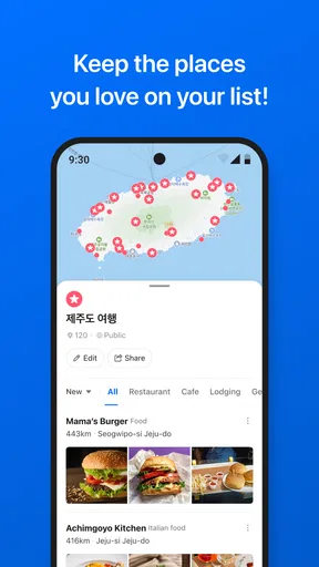
NAVER Maps provides a comprehensive navigation experience with real-time traffic updates, customizable routes, and public transit information. Users can benefit from voice-guided turn-by-turn directions, 3D maps, and detailed street views, making it ideal for both drivers and pedestrians. Additionally, it offers offline maps and points of interest to enhance travel planning.
Is NAVER Maps available for offline use?
Yes, NAVER Maps supports offline map usage. Users can download maps of specific regions or areas, allowing access to navigation features even without an internet connection. This is particularly useful for travelers who may encounter areas with poor connectivity or wish to save on data usage while navigating.
How accurate is the real-time traffic information on NAVER Maps?
NAVER Maps is known for its accurate real-time traffic updates, leveraging data from various sources to provide users with current traffic conditions. This includes road congestion, accidents, and construction updates, helping users select the fastest routes and avoid delays. However, accuracy can vary based on local data availability.
Can I customize my route on NAVER Maps?
Absolutely, NAVER Maps allows users to customize their routes based on preferences such as avoiding tolls or highways. Users can also add multiple stops along their route or select alternative routes provided by the app. This flexibility ensures a tailored navigation experience that suits individual travel needs.
Does NAVER Maps support public transportation navigation?
Yes, NAVER Maps offers robust public transportation navigation. It provides detailed transit schedules, route maps, and estimated travel times for buses, trains, and subways. Users can easily compare different transit options and receive notifications about delays or changes in schedules, making it a valuable tool for commuters.


